
SE Wyoming: Sunshine, Rain, And Snow Predicted For Upcoming Days
The Cheyenne Office of the National Weather Service is predicting a warming trend over the next few days, with rain and snow expected this weekend.
The agency posted the following on its website:
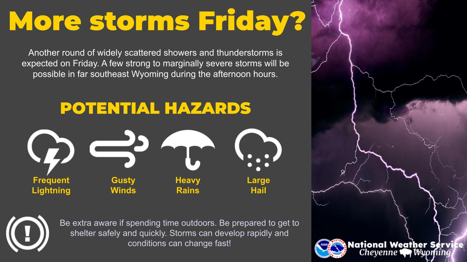
A quick warm-up is expected over the next few days with partly to mostly sunny skies. Slightly cooler, but unsettled weather will enter into the region Friday and continue through the weekend. Chances for precipitation will be possible during this time.

Get our free mobile app
Forecast for Today
High Wind Warning For Parts Of I-80
Cheyenne and Laramie Forecasts
Cheyenne Forecast
Today
Mostly sunny, with a high near 46. Breezy, with a west northwest wind 15 to 20 mph, with gusts as high as 30 mph.
Tonight
Partly cloudy, with a low around 25. Blustery, with a southwest wind 15 to 20 mph decreasing to 10 to 15 mph in the evening. Winds could gust as high as 30 mph.
Thursday
Partly sunny, with a high near 57. South southwest wind 10 to 15 mph.
Thursday Night
Mostly cloudy, with a low around 28. Southwest wind 5 to 15 mph becoming northwest after midnight.
Friday
A chance of snow before 10am, then rain and snow likely between 10am and 5pm, then rain likely after 5pm. Partly sunny, with a high near 50. Northwest wind 10 to 15 mph becoming east northeast in the afternoon. Chance of precipitation is 60%.
Friday Night
Rain before 9pm, then rain and snow between 9pm and 5am, then snow likely after 5am. Low around 27. Chance of precipitation is 80%.
Saturday
A chance of snow before 7am, then a chance of rain and snow between 7am and 1pm, then a chance of rain after 1pm. Mostly cloudy, with a high near 51. Chance of precipitation is 50%.
Saturday Night
Rain likely before 11pm, then rain and snow likely. Mostly cloudy, with a low around 27.
Sunday
A chance of rain and snow before 11am, then rain likely. Some thunder is also possible. Partly sunny, with a high near 50.
Sunday Night
Rain before 8pm, then rain and snow between 8pm and 11pm, then snow after 11pm. Mostly cloudy, with a low around 25.
Monday
A chance of snow. Mostly cloudy, with a high near 38. Breezy.
Monday Night
Partly cloudy, with a low around 20. Blustery.
Tuesday
Sunny, with a high near 48. Breezy.
Laramie Forecast:
Today
Patchy blowing snow between 9am and 1pm. Mostly sunny, with a high near 39. Breezy, with a west wind 15 to 25 mph, with gusts as high as 30 mph.
Tonight
Partly cloudy, with a low around 26. Breezy, with a southwest wind 10 to 20 mph, with gusts as high as 30 mph.
Thursday
Partly sunny, with a high near 51. Breezy, with a southwest wind 15 to 25 mph, with gusts as high as 35 mph.
Thursday Night
A chance of rain and snow showers before 10pm, then a chance of snow showers. Mostly cloudy, with a low around 27. Breezy, with a southwest wind 15 to 20 mph decreasing to 10 to 15 mph after midnight. Winds could gust as high as 30 mph. Chance of precipitation is 30%.
Friday
Snow likely, mainly after noon. Mostly cloudy, with a high near 46. West northwest wind around 10 mph. Chance of precipitation is 70%.
Friday Night
Snow. Low around 28. Chance of precipitation is 90%.
Saturday
Snow likely before 1pm, then rain and snow likely. Cloudy, with a high near 48. Chance of precipitation is 60%.
Saturday Night
Rain and snow, becoming all snow after 5am. Cloudy, with a low around 28.
Sunday
A chance of rain and snow before noon, then rain between noon and 4pm, then snow after 4pm. Mostly cloudy, with a high near 50. Breezy.
Sunday Night
Snow, mainly before midnight. Mostly cloudy, with a low around 23.
Monday
A chance of snow. Mostly cloudy, with a high near 38.
Monday Night
A slight chance of snow. Mostly cloudy, with a low around 17.
Tuesday
Mostly sunny, with a high near 42.
THE HISTORY & REBIRTH OF CHUGWATER WYOMING
Gallery Credit: Glenn Woods