The Cheyenne Office of the National Weather Service late Wednesday morning updates the available information on a two-fold blast of winter weather in southeast Wyoming.

101.9 KING-FM logo
Get our free mobile app

The agency posted the following on its website:

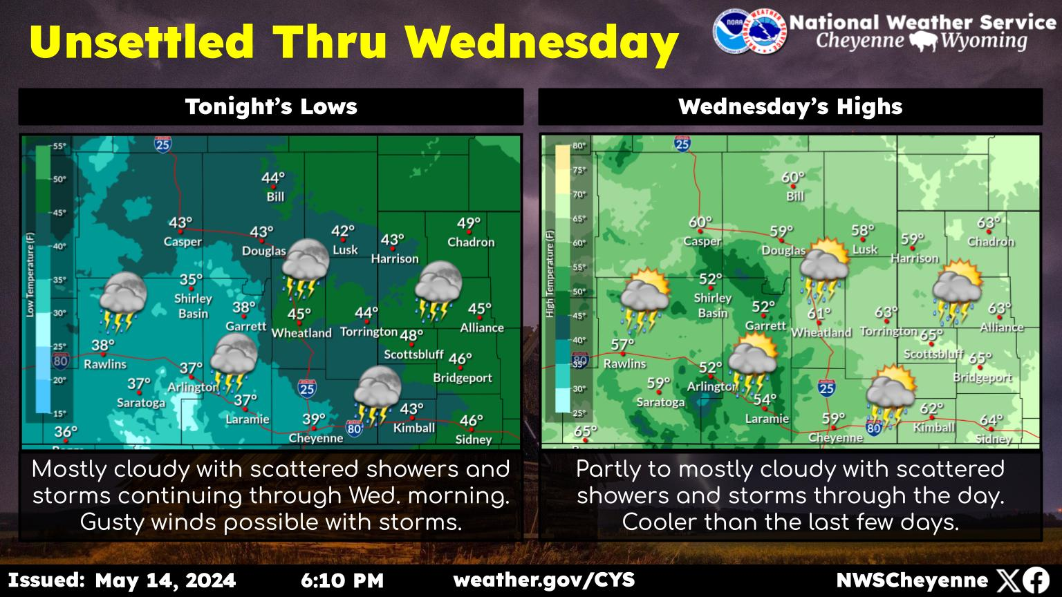
Into the cold we go! Last nice day of Fall before we cool off with series of cold fronts moving through the region Thursday and again Late Friday. Now is the time to finalize winter and colder temperature preparations. Teens to single digit lows expected this weekend into early next week. Highs will struggle to reach freezing Saturday. Two rounds of light snow with first one Thursday into early Friday and second (slightly more potent) Friday night through the day Saturday. Overall amounts should be low (trace-3 inches) valleys to High Plains but some winter weather advisories could be issued for the mountains with 4-8 inches probable.


Here is the forecast for Cheyenne:

This Afternoon
Sunny, with a high near 65. South southwest wind 10 to 15 mph.
Tonight
Mostly clear, with a low around 32. South southwest wind around 10 mph becoming north northwest after midnight.
Thursday
A 20 percent chance of rain after noon. Partly sunny, with a high near 55. North wind 10 to 15 mph becoming south in the afternoon.
Thursday Night
A slight chance of rain and snow before 7pm, then a slight chance of snow between 7pm and midnight. Mostly cloudy, with a low around 18. Southeast wind 10 to 15 mph becoming north northwest after midnight. Winds could gust as high as 25 mph. Chance of precipitation is 20%.
Friday
Mostly sunny, with a high near 42. North northwest wind 10 to 15 mph becoming south southeast in the afternoon.
Friday Night
A 30 percent chance of snow after midnight. Mostly cloudy, with a low around 19.
Saturday
Snow likely, mainly after noon. Mostly cloudy, with a high near 30. Chance of precipitation is 60%.
Saturday Night
Snow likely, mainly before midnight. Mostly cloudy, with a low around 10.
Sunday
A slight chance of snow before noon. Mostly sunny, with a high near 29.
Sunday Night
A chance of flurries. Mostly clear, with a low around 10.
Monday
Sunny, with a high near 38.
Monday Night
Mostly clear, with a low around 12.
Tuesday
Sunny, with a high near 42.
Here is the Laramie Forecast:
This Afternoon
Sunny, with a high near 63. Breezy, with a west southwest wind 15 to 20 mph, with gusts as high as 35 mph.
Tonight
Partly cloudy, with a low around 41. West southwest wind 10 to 15 mph.
Thursday
A 30 percent chance of rain after noon. Partly sunny, with a high near 53. Breezy, with a south southwest wind 10 to 20 mph, with gusts as high as 30 mph.
Thursday Night
A 20 percent chance of snow before midnight. Partly cloudy, with a low around 23. Breezy, with a west northwest wind 15 to 20 mph decreasing to 10 to 15 mph after midnight. Winds could gust as high as 30 mph.
Friday
Mostly sunny, with a high near 43. West wind 5 to 15 mph becoming south in the afternoon.
Friday Night
A 30 percent chance of snow, mainly after midnight. Mostly cloudy, with a low around 21.
Saturday
Snow likely, mainly after noon. Mostly cloudy, with a high near 29. Chance of precipitation is 70%.
Saturday Night
A chance of snow. Mostly cloudy, with a low around 11.
Sunday
A slight chance of snow before noon, then a chance of flurries after noon. Mostly sunny, with a high near 24.
Sunday Night
A chance of flurries. Mostly clear, with a low around 12.
Monday
Sunny, with a high near 33.
Monday Night
Mostly clear, with a low around 15.
Tuesday
Sunny, with a high near 38.

Most Extreme October Weather In Cheyenne

A look back at some of October's wildest weather

More From 101.9 KING-FM