Smokey, Hazy Wyoming Skies Again Monday and Tuesday

The Cheyenne Office of the National Weather Service has issued a special weather statement for parts of Wyoming and the Nebraska Panhandle for August 24 and 25.
The statement reads as follows:
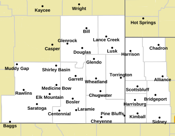
NEZ002-003-019>021-054-055-095-096-WYZ101>119-251200-
Dawes-Box Butte-Scotts Bluff County-Banner County-Morrill-
Kimball County-Cheyenne-North Sioux-South Sioux-
Converse County Lower Elevations-Niobrara County-
North Laramie Range-Ferris/Seminoe/Shirley Mountains-
Shirley Basin-Central Laramie Range and Southwest Platte County-
East Platte County-Goshen County-Central Carbon County-
North Snowy Range Foothills-Southwest Carbon County-
Sierra Madre Range-Upper North Platte River Basin-Snowy Range-
Laramie Valley-South Laramie Range-South Laramie Range Foothills-
Central Laramie County-East Laramie County-
Including the cities of Chadron, Chadron St Park, Alliance,
Scottsbluff, Gering, Harrisburg, Angora, Bridgeport, Bayard,
Redington, Kimball, Brownson, Sidney, Harrison, Agate, Bill,
Douglas, Deer Creek, Glenrock, Lusk, Redbird, Garrett,
Seminoe Dam, Medicine Bow, Shirley Basin, Bordeaux, Wheatland,
Guernsey, Torrington, Rawlins, Arlington, Elk Mountain, Baggs,
Saratoga, Encampment, Centennial, Albany, Bosler, Laramie,
Buford, Pumpkin Vine, Vedauwoo, Whitaker, Federal, Horse Creek,
Cheyenne, and Pine Bluffs
606 AM MDT Mon Aug 24 2020

Clockwise circulation around a stationary high pressure system over
the southwestern United States will transport smoke from California
and Colorado wildfires into much of southeast Wyoming and the western
Nebraska Panhandle through Tuesday morning. Surface visibilities may
be reduced to five miles at times over southeast Wyoming. Persons
with respiratory ailments should avoid prolonged exposure to the
smoke and poor air quality.
Top 5 Coffee, Tea Spots in Cheyenne According to Yelp
More From 101.9 KING-FM