Cheyenne and Laramie ae facing High Wind Warnings on Tuesday, with possible snow. That combination could lead to poor visibility and dangerous driving conditions, especially for light, high profile vehicles.

Meanwhile, the Sierra Madre and Snowy Range mountain ranges in southeast Wyoming are facing Winter Storm Warnings and Winter Weather Advisories.

All of southeast Wyoming could also receive much-needed snow as the week continues.

That's all according to the Cheyenne Office of the National Weather Service. The agency posted the following on its website:

The agency issued a decision packet that includes the following key points:

Key Messages: 

·  A High Wind Warning has been issued for all of Southeast Wyoming outside of our mountain zones. High Wind Warning has been expanded to the entirety of the Nebraska Panhandle.


·  Critical to Extreme Fire Weather conditions expected on Tuesday, with Red Flag Warnings in effect for the Nebraska Panhandle and portions of Southeast Wyoming.


·  Winter Weather concerns are expected Tuesday and again Wednesday into Thursday, with a Winter Storm Warning in effect for the Sierra-Madre range, and Winter Weather Advisories as well for the Snowy range as well as the Arlington area. Passing snow showers could also produce snow squalls for the lower elevations overnight tonight into Tuesday evening.


Recent Updates: 

·  High Wind Warnings for the western Nebraska panhandle.


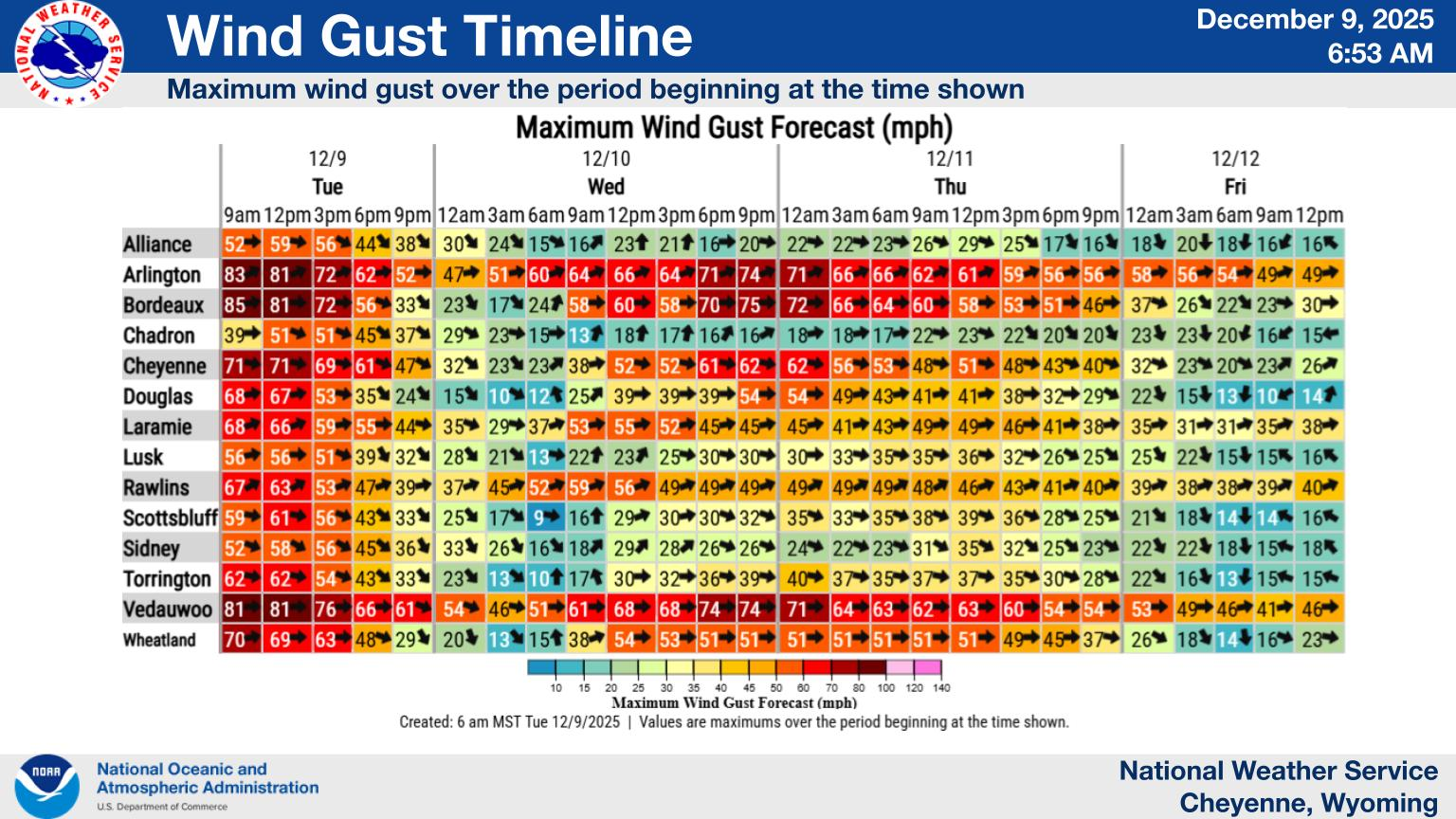
·  Added timeline slides for winds and snow.


Tuesday will see several winter weather concerns across the region. A Winter Storm Warning and a Winter Weather Advisory have been issued for the Sierra-Madre and Snowy Ranges respectfully, alongside an Advisory for the Arlington area as well. Snow squalls will also be possible outside of these regions, primarily west of I-25.


The other major issue is strong winds, according to the National Weather Service:

High Wind Warnings have been issued for most of Southeast Wyoming for late Monday through Tuesday evening. High Wind Watches are also in effect for the Nebraska Panhandle for Tuesday, with higher uncertainty in winds reaching High Wind status (58+ mph).


Despite the possible snow, Red Flag Fire Warnings are also in effect in some areas:

Red Flag Warnings have been issued across the Nebraska Panhandle and portions of Southeast Wyoming on Tuesday, with high wind gusts alongside relative humidities into the teens to nearing single digits for the day. Rapid fire spread is expected to be possible.


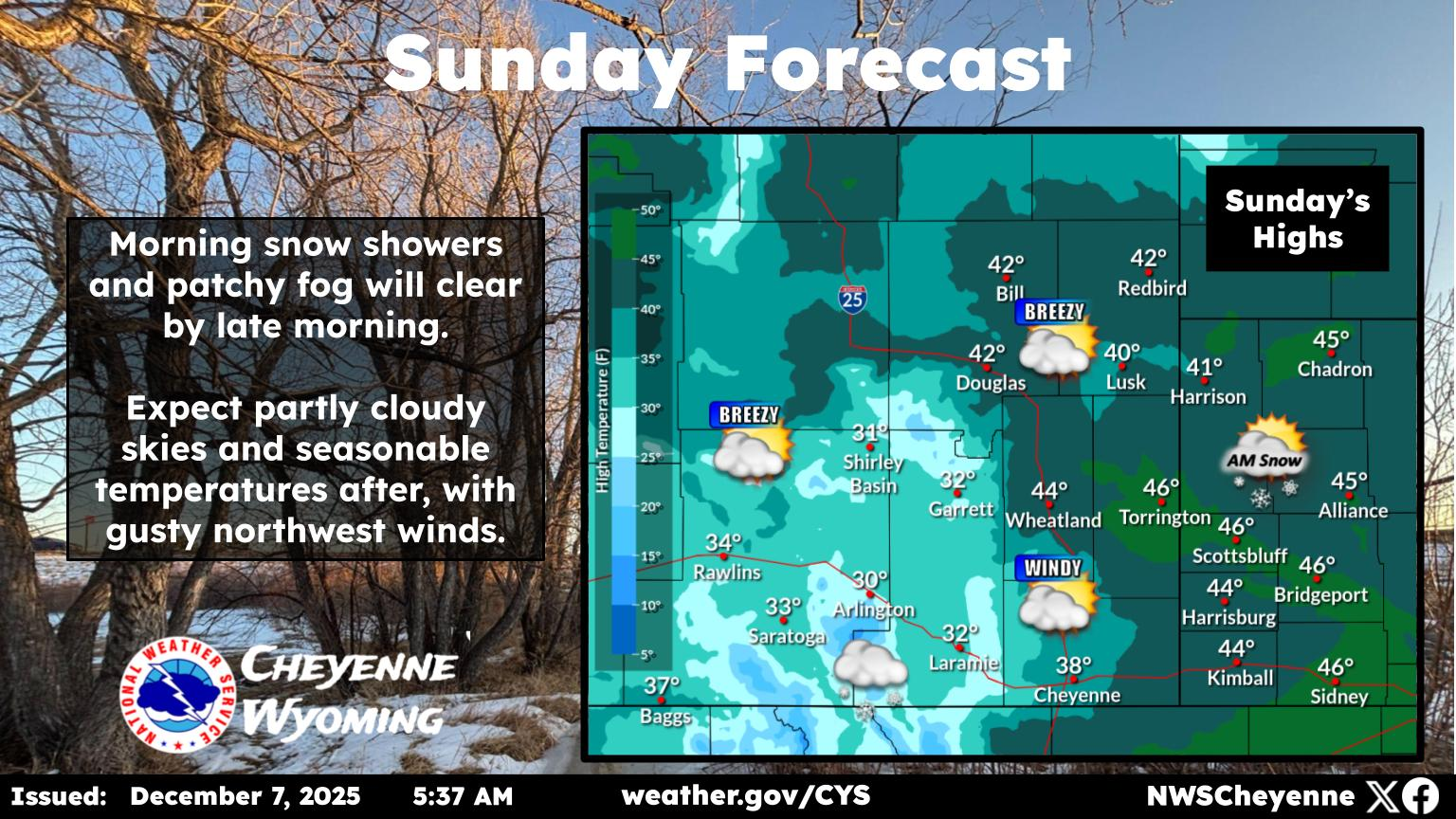
Cheyenne, Laramie Forecasts

Cheyenne Forecast

Today
Mostly sunny, with a high near 47. Windy, with a west wind 40 to 45 mph decreasing to 35 to 40 mph in the afternoon. Winds could gust as high as 70 mph.
Tonight
Mostly clear, with a low around 23. Breezy, with a west wind 20 to 25 mph decreasing to 15 to 20 mph after midnight. Winds could gust as high as 40 mph.
Wednesday
A 40 percent chance of snow after 11am. Increasing clouds, with a high near 47. South southwest wind 10 to 15 mph.
Wednesday Night
Snow likely, mainly before 11pm. Mostly cloudy, with a low around 14. Windy, with a west northwest wind 15 to 20 mph increasing to 25 to 30 mph after midnight. Winds could gust as high as 45 mph. Chance of precipitation is 60%. New snow accumulation of around an inch possible.
Thursday
A 20 percent chance of snow after 11am. Mostly sunny, with a high near 30. Windy, with a west northwest wind 20 to 30 mph, with gusts as high as 40 mph.
Thursday Night
Partly cloudy, with a low around 10.
Friday
A 30 percent chance of snow after 11am. Partly sunny, with a high near 31.
Friday Night
A chance of snow showers, mainly before 11pm. Partly cloudy, with a low around 12.
Saturday
Sunny, with a high near 36. Breezy.
Saturday Night
Mostly clear, with a low around 12.
Sunday
Mostly sunny, with a high near 40.
Sunday Night
Mostly clear, with a low around 20.
Monday
Sunny, with a high near 55.
Laramie Forecast
Today
Scattered snow showers, mainly after 2pm. Patchy blowing snow after 2pm. Partly sunny, with a high near 37. Windy, with a west wind 40 to 45 mph, with gusts as high as 65 mph. Chance of precipitation is 50%.
Tonight
Scattered snow showers between 11pm and 2am. Areas of blowing snow before 8pm. Partly cloudy, with a low around 22. Windy, with a west wind 30 to 40 mph decreasing to 20 to 30 mph after midnight. Winds could gust as high as 60 mph. Chance of precipitation is 30%.
Wednesday
Isolated snow showers before 11am, then snow likely after 11am. Partly sunny, with a high near 39. Breezy, with a southwest wind 20 to 25 mph, with gusts as high as 35 mph. Chance of precipitation is 60%. New snow accumulation of less than one inch possible.
Wednesday Night
Snow likely, mainly before 11pm. Mostly cloudy, with a low around 12. Wind chill values between -10 and zero. Windy, with a west wind 25 to 30 mph increasing to 30 to 35 mph after midnight. Winds could gust as high as 55 mph. Chance of precipitation is 70%. New snow accumulation of 1 to 2 inches possible.
Thursday
A 30 percent chance of snow after 11am. Mostly sunny, with a high near 22. Windy, with a west wind 30 to 35 mph, with gusts as high as 55 mph.
Thursday Night
A 20 percent chance of snow after 11pm. Partly cloudy, with a low around 8. Breezy.
Friday
A 50 percent chance of snow after 11am. Partly sunny, with a high near 25. Breezy.
Friday Night
A chance of snow showers, mainly before 11pm. Partly cloudy, with a low around 9. Breezy.
Saturday
A slight chance of snow showers after 11am. Sunny, with a high near 24. Breezy.
Saturday Night
Mostly clear, with a low around 11.
Sunday
Mostly sunny, with a high near 35.
Sunday Night
Mostly clear, with a low around 22.
Monday
Sunny, with a high near 45. Breezy.

Check Out the Sun Halos Above Cheyenne

The amazing natural phenomenon began Thursday morning. A dazzling double halo, sun dogs, and rainbows appeared in the blue skies above Cheyenne.

Gallery Credit: Phylicia Peterson, Townsquare Media Laramie/Cheyenne