The Cheyenne Office of the National Weather Service is now saying that bands of locally heavy snow are possible in the Cheyenne area this evening, along with flash freeze conditions and wind chills that could reach - 5 degrees.

The agency updated its forecast to include the following:

Winter weather makes its return today as a strong cold front sweeps through the region into Colorado by sunset today. Accumulating snowfall is anticipated outside of the headline areas, but it will take time to occur due to a later switch over to snow from rain showers, which will limit accumulations. Gusty winds along the I-80 corridor are likely this evening, especially from Cheyenne to Sidney. Additional areas may be included in Winter Weather Advisory headlines so stay tuned to forecast updates

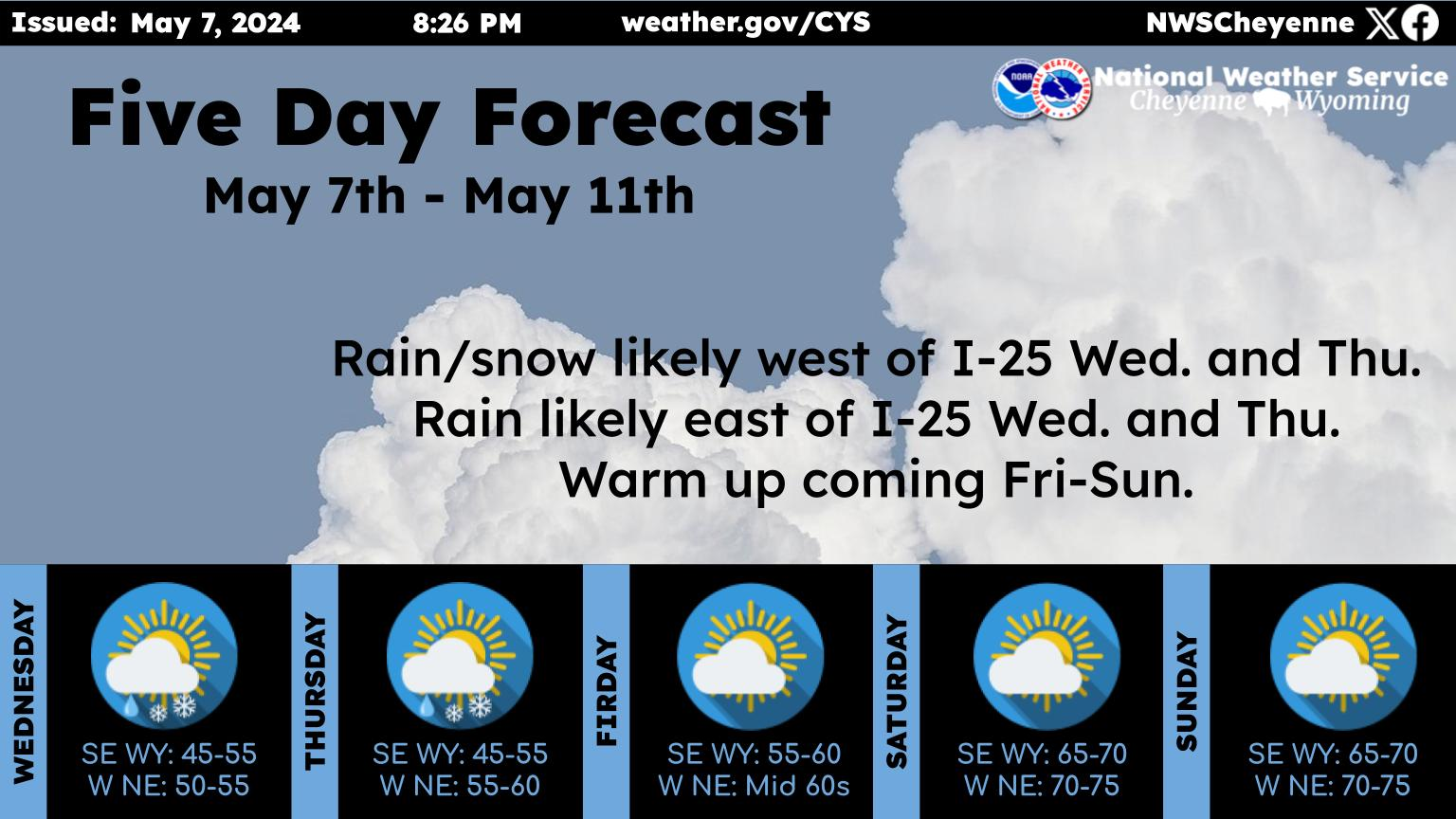
Cheyenne, Laramie Forecasts

Cheyenne Forecast:

This Afternoon
A chance of rain showers before 1pm, then rain and snow showers between 1pm and 4pm, then snow showers after 4pm. Patchy blowing snow after 5pm. High near 47. Breezy, with a north wind 10 to 15 mph increasing to 20 to 25 mph. Winds could gust as high as 35 mph. Chance of precipitation is 90%. Total daytime snow accumulation of 2 to 4 inches possible.
Tonight
Snow showers, mainly before midnight. Patchy blowing snow before midnight. Low around 14. Wind chill values between -5 and 5. Windy, with a north wind 30 to 35 mph decreasing to 25 to 30 mph after midnight. Winds could gust as high as 50 mph. Chance of precipitation is 90%. New snow accumulation of less than one inch possible.
Monday
A chance of flurries before noon. Mostly cloudy, with a high near 26. Wind chill values between -5 and 5. Windy, with a north wind 20 to 30 mph, with gusts as high as 40 mph.
Monday Night
Partly cloudy, with a low around 12. Blustery, with a north wind 15 to 20 mph becoming west northwest 5 to 10 mph after midnight.
Tuesday
A 30 percent chance of snow showers after noon. Partly sunny, with a high near 39. West northwest wind 5 to 10 mph becoming north northeast in the afternoon.
Tuesday Night
A 20 percent chance of snow showers before midnight. Mostly cloudy, with a low around 22.
Wednesday
Mostly sunny, with a high near 45. Breezy.
Wednesday Night
Mostly clear, with a low around 27. Breezy.
Thursday
Mostly sunny, with a high near 56. Breezy.
Thursday Night
Partly cloudy, with a low around 33.
Friday
Mostly sunny, with a high near 55.
Friday Night
A chance of rain and snow showers. Mostly cloudy, with a low around 30.
Saturday
A chance of rain and snow showers. Partly sunny, with a high near 54.
Laramie Forecast:
This Afternoon
Snow showers. Patchy blowing snow after 4pm. Temperature falling to around 26 by 5pm. Breezy, with a west northwest wind 10 to 15 mph becoming north northeast 20 to 25 mph. Winds could gust as high as 35 mph. Chance of precipitation is 100%. Total daytime snow accumulation of 3 to 5 inches possible.
Tonight
Snow showers, mainly before midnight. Widespread blowing snow, mainly between 9pm and midnight. Low around 8. Wind chill values between -5 and -15. Windy, with a north northeast wind around 30 mph becoming northwest after midnight. Winds could gust as high as 45 mph. Chance of precipitation is 100%. New snow accumulation of 1 to 3 inches possible.
Monday
A slight chance of snow showers before noon, then a chance of flurries after noon. Patchy blowing snow. Mostly cloudy, with a high near 20. Wind chill values between -5 and -15. Blustery, with a north northwest wind 20 to 25 mph, with gusts as high as 40 mph. Chance of precipitation is 20%.
Monday Night
A chance of flurries before midnight, then a slight chance of snow showers after midnight. Patchy blowing snow before 7pm. Mostly cloudy, with a low around 12. Wind chill values between zero and 5. Blustery, with a north northwest wind 15 to 20 mph becoming southwest 10 to 15 mph after midnight. Winds could gust as high as 30 mph. Chance of precipitation is 20%.
Tuesday
Snow showers likely, mainly after noon. Partly sunny, with a high near 29. Blustery, with a west wind 10 to 15 mph increasing to 20 to 25 mph in the afternoon. Chance of precipitation is 60%.
Tuesday Night
A 30 percent chance of snow showers before midnight. Mostly cloudy, with a low around 18. Blustery.
Wednesday
A 20 percent chance of snow showers after noon. Mostly sunny, with a high near 34. Windy.
Wednesday Night
Mostly clear, with a low around 25. Windy.
Thursday
Partly sunny, with a high near 44. Breezy.
Thursday Night
A slight chance of snow showers before midnight. Partly cloudy, with a low around 29. Breezy.
Friday
A slight chance of snow showers. Mostly sunny, with a high near 43. Breezy.
Friday Night
A chance of snow showers. Mostly cloudy, with a low around 28. Breezy.
Saturday
A chance of snow showers. Partly sunny, with a high near 44. Breezy.

10 Commandments of Wyoming Winter Driving

Gallery Credit: DJ Nyke