Winter Conditions Force I-80 in Southeast Wyoming to Shut Down Again
UPDATE:
The westbound lanes from Cheyenne to Laramie are now closed due to rolling closure.
As of 5:30 p.m., the estimated opening time is in 13 to 15 hours.
UPDATE:
As of 4 p.m., the estimated opening time is in 14 to 16 hours.
UPDATE:
The eastbound lanes from Rock Springs to Rawlins are now closed due to rolling closure.
As of 3:39 p.m., the estimated opening time is unknown.
ORIGINAL STORY:
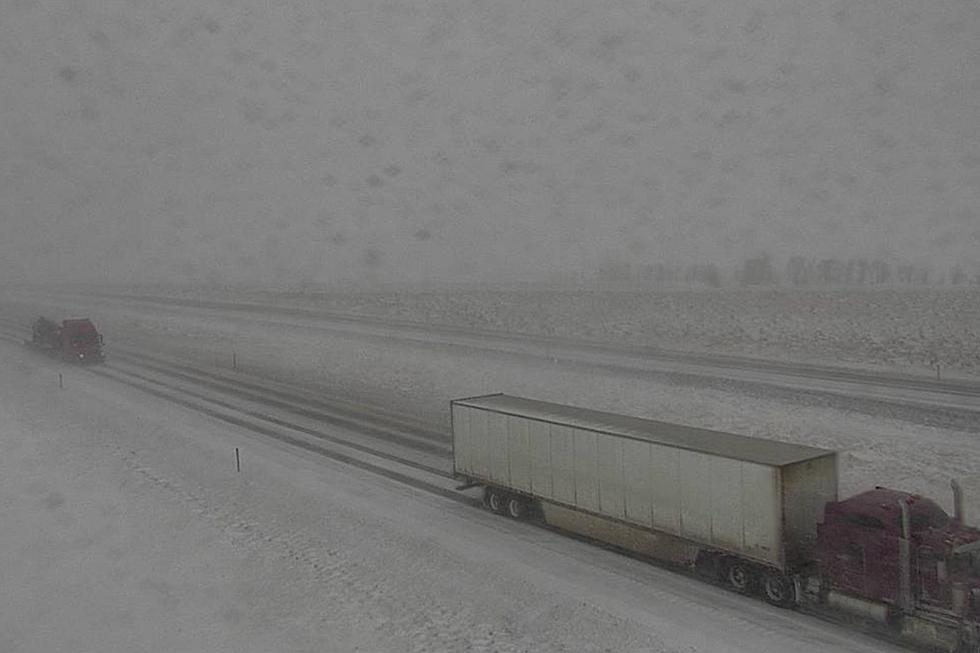
Winter conditions have once again forced the closure of Interstate 80 between Rawlins and Laramie in southeast Wyoming.
As of 2:24 p.m., the Wyoming Department of Transportation did not have an estimate as to when the roughly 100-mile stretch might reopen.
Reduced visibility is also being reported between Laramie and Cheyenne, but as of 3:08 p.m., the stretch was still open.

A Winter Weather Advisory remains in effect until 11 p.m. tonight for the Sierra Madre and Snowy Ranges.
Total snow accumulations of 4 to 8 inches above 8,000 feet and winds gusting as high as 45 mph are expected.
After a lull through most of the day Saturday, another Winter Weather Advisory is in effect from 8 p.m. Saturday to 5 p.m. Sunday for an additional 6 to 11 inches of snow and up to 60 mph wind gusts.
URGENT - WINTER WEATHER MESSAGE
National Weather Service Cheyenne WY
109 PM MST Fri Mar 3 2023

WYZ112-114-041200-
/O.CON.KCYS.WW.Y.0014.000000T0000Z-230304T0600Z/
/O.CON.KCYS.WW.Y.0015.230305T0300Z-230306T0000Z/
Sierra Madre Range-Snowy Range-
Including the cities of Centennial and Albany
109 PM MST Fri Mar 3 2023

...WINTER WEATHER ADVISORY REMAINS IN EFFECT UNTIL 11 PM MST THIS
EVENING...
...WINTER WEATHER ADVISORY REMAINS IN EFFECT FROM 8 PM SATURDAY TO
5 PM MST SUNDAY...

* WHAT...For the first Winter Weather Advisory, snow and blowing
  snow expected. Total snow accumulations of 4 to 8 inches above
  8000 feet. Winds gusting as high as 45 MPH. For the second
  Winter Weather Advisory, snow and blowing snow expected. Total
  snow accumulations of 6 to 11 inches above 8000 feet. Winds
  gusting as high as 60 MPH.

* WHERE...Sierra Madre Range and Snowy Range.

* WHEN...For the first Winter Weather Advisory, until 11 PM MST
  this evening. For the second Winter Weather Advisory, from 8
  PM Saturday to 5 PM MST Sunday.

* IMPACTS...Travel could be very difficult to impossible.
  Widespread blowing snow could significantly reduce visibility.
  The hazardous conditions could impact the morning and evening
  commutes. Wind chills as low as 25 degrees below zero could
  cause frostbite on exposed skin in as little as 30 minutes.

PRECAUTIONARY/PREPAREDNESS ACTIONS...

Slow down and use caution while traveling.

The latest road conditions for the state you are calling from can
be obtained by calling 5 1 1.
Drivers are encouraged to call 911 or visit wyoroad.info for the latest road conditions and closure information.
READ MORE:
WYDOT Urges 'Don't Crowd the Plow!' After 67 Plows Hit in 3 Years
More From 101.9 KING-FM
![[BREAKING] Cheyenne’s Fridays on the Plaza Schedule Packs a Punch](http://townsquare.media/site/98/files/2023/05/attachment-fridays-on-the-plaza-1.jpg?w=980&q=75)