The Cheyenne Office of the National Weather Service has posted Winter Storm and Blizzard warnings for much of southeast Wyoming into Wednesday.

Both Cheyenne and Laramie can expect snow, bitterly cold wind chills, and winds of 55-60 miles per hour, according to the weather service

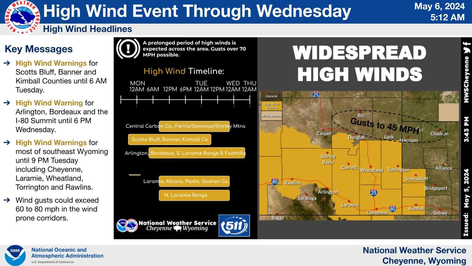
The agency posted the following on its website:


Here's a look at the current Blizzard, Winter Storm, and High Wind Warnings in effect for our area. Most are in effect until 5AM Wednesday. The greatest impacts are expected along the Pine Ridge, Cheyenne Ridge, and southern Laramie range.

The summit between Cheyenne and Laramie is under a blizzard warning, with winds of up to 75 miles per hour possible:

Here is a look at snowfall projections:

The agency posted this timeline:

Cheyenne and Laramie forecasts:

Cheyenne Forecast:

Today
A 50 percent chance of snow. Widespread blowing snow, mainly after 11am. Partly sunny, with a high near 31. Wind chill values between zero and 10. Windy, with a northwest wind 35 to 40 mph, with gusts as high as 60 mph.
Tonight
A 30 percent chance of snow, mainly before 11pm. Widespread blowing snow, mainly before 9pm. Mostly cloudy, with a steady temperature around 26. Windy, with a northwest wind 20 to 30 mph, with gusts as high as 45 mph.
Wednesday
Patchy blowing snow before 11am. Mostly sunny, with a high near 38. Breezy, with a northwest wind 15 to 20 mph, with gusts as high as 30 mph.
Wednesday Night
Mostly clear, with a low around 16. West northwest wind around 10 mph.
Thursday
Sunny, with a high near 42. West northwest wind around 10 mph.
Thursday Night
Mostly clear, with a low around 18.
Friday
Sunny, with a high near 45.
Friday Night
Mostly clear, with a low around 21.
Saturday
Sunny, with a high near 45.
Saturday Night
Mostly clear, with a low around 20.
Sunday
Sunny, with a high near 45.
Sunday Night
Mostly clear, with a low around 22.
New Year's Day
Mostly sunny, with a high near 46.
Laramie Forecast:
Today
A 40 percent chance of snow. Patchy blowing snow. Cloudy, with a high near 27. Wind chill values between zero and 10. Blustery, with a northwest wind around 25 mph, with gusts as high as 40 mph.
Tonight
A 20 percent chance of snow before 11pm. Patchy blowing snow before 8pm. Mostly cloudy, with a low around 13. Blustery, with a northwest wind 15 to 20 mph decreasing to 10 to 15 mph after midnight. Winds could gust as high as 30 mph.
Wednesday
Mostly sunny, with a high near 33. Northwest wind around 10 mph.
Wednesday Night
Mostly clear, with a low around 5. Wind chill values between -5 and zero. Southwest wind around 5 mph.
Thursday
Sunny, with a high near 35. Southwest wind 5 to 10 mph becoming west northwest in the afternoon.
Thursday Night
Mostly clear, with a low around 7.
Friday
Mostly sunny, with a high near 37.
Friday Night
Partly cloudy, with a low around 13.
Saturday
Sunny, with a high near 39.
Saturday Night
Mostly clear, with a low around 11.
Sunday
Sunny, with a high near 36.
Sunday Night
Mostly clear, with a low around 13.
New Year's Day
Mostly sunny, with a high near 35.

10 of Wyoming's Most Dangerous Animals

Wyoming is home to some pretty epic creatures. The pronghorn is the second fastest land animal in the world, second only to the cheetah -- and it's worth noting that while the cheetah can spring faster, the pronghorn can sustain it's top speed much farther. And while we do have plenty of cute and cuddly creatures (llike the nothern saw-whet owl) there are plenty of things that'll kill ya. Might want to think twice about moving here.

More From 101.9 KING-FM