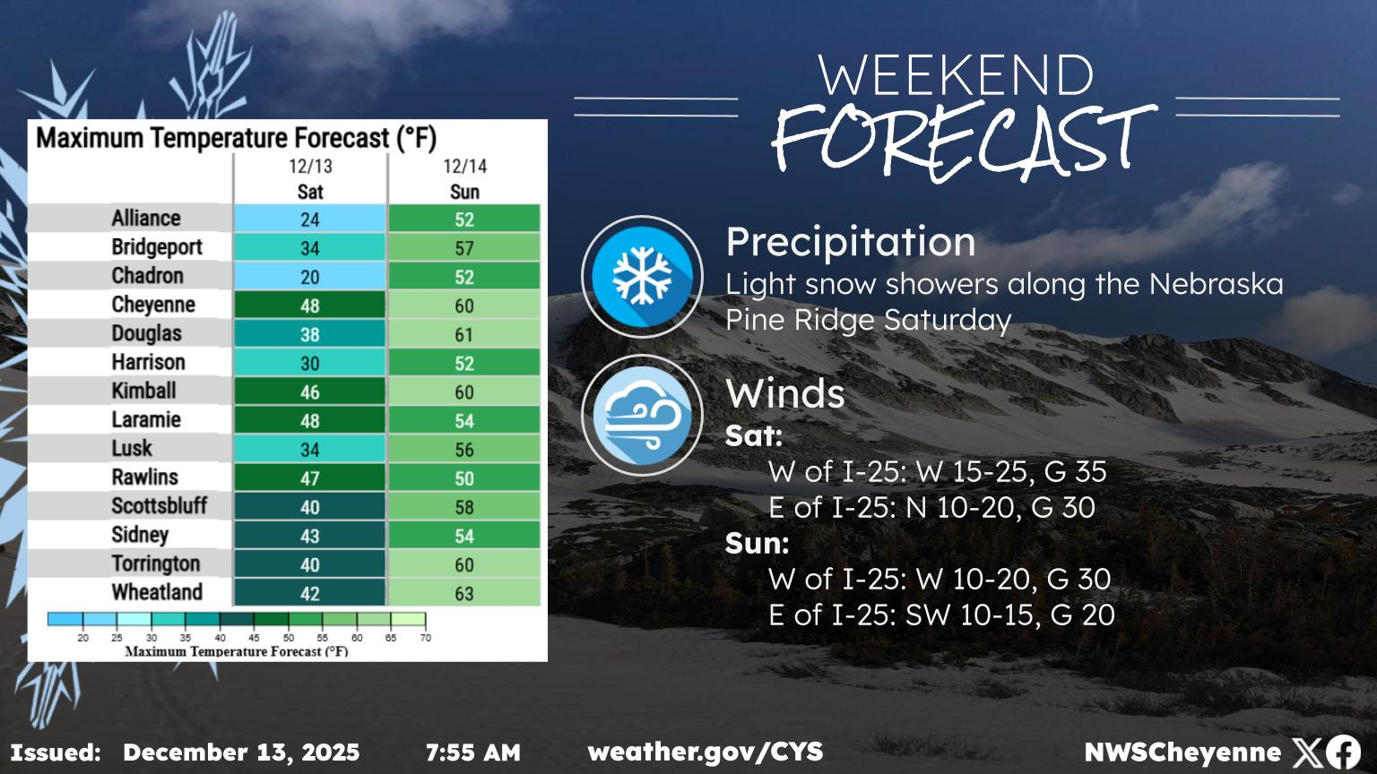
The Cheyenne Office of the National Weather Service says southeast Wyoming can expect more snow through Saturday, with brutally cold wind chill temperatures in the forecast for Friday and Saturday.

That includes wind chills in the -7 degree or colder range for Cheyenne and Laramie.

The agency posted the following on it's website:

"Very cold air has moved into the region this morning with temperatures struggling to reach 30F today. Clearing skies tonight will help temperatures drop significantly, and with a light breeze, wind chill values are expected to be well below 0F both Friday morning and Saturday morning. Make sure to bundle up this morning, as well as Friday and Saturday."


Cheyenne, Laramie Forecasts

Cheyenne Weather

Today
A 20 percent chance of snow showers after 2pm. Partly sunny, with a high near 28. Blustery, with a west northwest wind 20 to 25 mph, with gusts as high as 35 mph.
Tonight
A 20 percent chance of snow showers after 2am. Mostly clear, with a low around 5. Wind chill values between -5 and zero. West northwest wind 5 to 10 mph becoming southwest after midnight.
Friday
Snow showers likely, mainly after 11am. Mostly cloudy, with a high near 25. Wind chill values between -5 and 5. South wind 5 to 15 mph becoming east northeast in the afternoon. Chance of precipitation is 60%. New snow accumulation of less than a half inch possible.
Friday Night
A 40 percent chance of snow showers, mainly before 11pm. Mostly cloudy, then gradually becoming mostly clear, with a low around 9. Wind chill values between -5 and 5. West wind 5 to 15 mph, with gusts as high as 25 mph.
Saturday
Patchy blowing snow between 9am and 2pm. Sunny, with a high near 37. Breezy, with a west northwest wind 15 to 25 mph, with gusts as high as 35 mph.
Saturday Night
Mostly clear, with a low around 10.
Sunday
Mostly sunny, with a high near 40.
Sunday Night
Mostly clear, with a low around 18.
Monday
Mostly sunny, with a high near 54.
Monday Night
Mostly cloudy, with a low around 32.
Tuesday
Partly sunny, with a high near 56. Breezy.
Tuesday Night
A slight chance of showers. Mostly cloudy, with a low around 32. Breezy.
Wednesday
A chance of rain and snow showers. Partly sunny, with a high near 52. Breezy.
Laramie Forecast
Today
A 20 percent chance of snow showers after 11am. Partly sunny, with a high near 21. Wind chill values between zero and 5. Breezy, with a west wind 20 to 25 mph, with gusts as high as 35 mph.
Tonight
Mostly clear, with a low around 5. Wind chill values between -5 and zero. West wind 5 to 15 mph becoming south southeast after midnight.
Friday
Snow showers likely, mainly after 11am. Mostly cloudy, with a high near 22. Wind chill values between -5 and 5. South southeast wind 5 to 10 mph becoming north in the afternoon. Chance of precipitation is 70%. New snow accumulation of less than one inch possible.
Friday Night
A 40 percent chance of snow showers, mainly before 11pm. Mostly cloudy, then gradually becoming mostly clear, with a low around 8. Wind chill values between -10 and zero. West wind 10 to 15 mph.
Saturday
Patchy blowing snow between 10am and 4pm. Sunny, with a high near 31. Breezy, with a west wind 15 to 25 mph, with gusts as high as 35 mph.
Saturday Night
Mostly clear, with a low around 11.
Sunday
Mostly sunny, with a high near 39.
Sunday Night
Mostly clear, with a low around 20.
Monday
Mostly sunny, with a high near 47.
Monday Night
Mostly cloudy, with a low around 30.
Tuesday
Partly sunny, with a high near 48. Breezy.
Tuesday Night
A chance of snow showers. Mostly cloudy, with a low around 29.
Wednesday
A chance of snow showers. Mostly cloudy, with a high near 43. Breezy.

Lunar Rainbow: Why the Moon Changes Colors, Explained

When the moon lies on the horizon, the color will be most intense, usually red or orange. When there's more blue light, as during the early morning hours, we're more likely to see purple and blue-tinged moons. Here's why:

Gallery Credit: Phylicia Peterson, Townsquare Media Laramie/Cheyenne

More From 101.9 KING-FM