NWS Cheyenne: Incoming Snowstorm Could Bring Blizzard Conditions
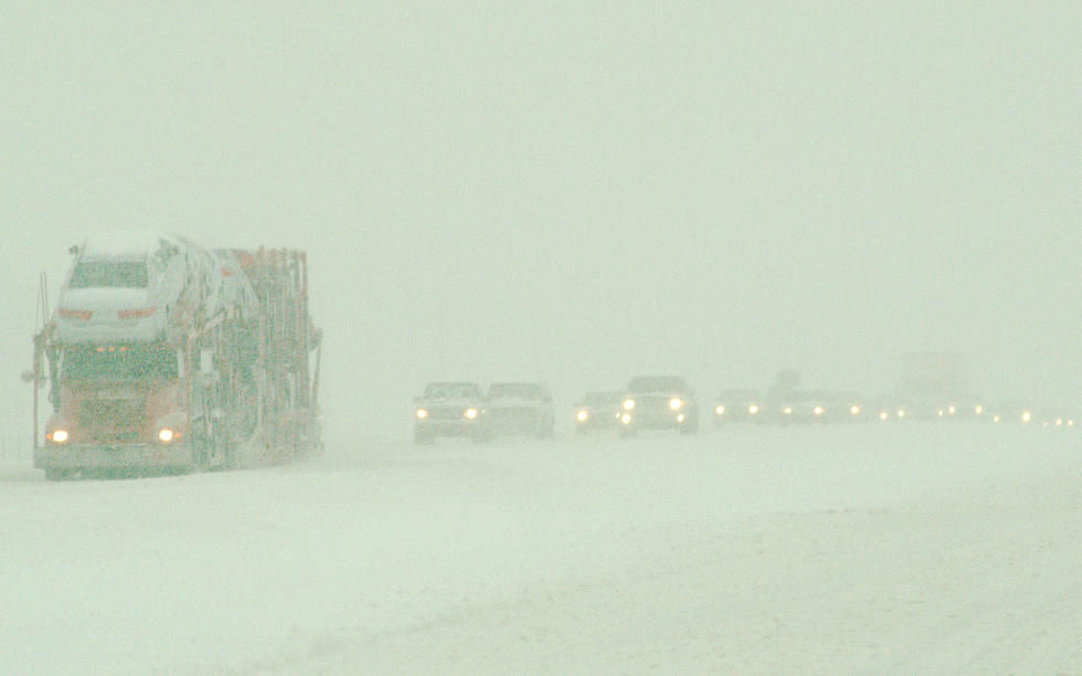
Heavy mountain snow combined with gusty winds could make for blizzard conditions along portions of Interstate 80 in southeast Wyoming Thursday through early this weekend.
The National Weather Service in Cheyenne issued the following messages Wednesday afternoon:

A Winter Storm Warning is in effect for the Snowy and Sierra Madre Ranges from 3 PM Thursday to 11 AM Christmas morning. Heavy snow is expected with total snowfall accumulations up to 24 inches for the Snowy Range and 36 inches for the Sierra Madre Range. Winds will gust as high as 55 mph. For the lower elevations, there is a Winter Storm Watch from Thursday afternoon into Friday afternoon. Total snowfall of 5 to 8 inches will be possible along with possible blizzard conditions.

URGENT - WINTER WEATHER MESSAGE
National Weather Service Cheyenne WY
155 PM MST Wed Dec 22 2021

...HEAVY SNOW EXPECTED FOR THE MOUNTAINS THURSDAY THROUGH EARLY
THIS WEEKEND...

WYZ112-114-231200-
/O.UPG.KCYS.WS.A.0013.211223T2200Z-211225T1800Z/
/O.NEW.KCYS.WS.W.0019.211223T2200Z-211225T1800Z/
Sierra Madre Range-Snowy Range-
Including the cities of Centennial and Albany
155 PM MST Wed Dec 22 2021

...WINTER STORM WARNING IN EFFECT FROM 3 PM THURSDAY TO 11 AM MST
SATURDAY...

* WHAT...Heavy snow expected. Total snow accumulations of up to 3
  feet for the Sierra Madre Range and 2 feet for the Snowy Range.
  Winds gusting as high as 55 mph.

* WHERE...Sierra Madre Range and Snowy Range in southeast Wyoming.

* WHEN...From 3 PM Thursday to 11 AM MST Saturday.

* IMPACTS...Travel could be very difficult to impossible. Patchy
  blowing snow could significantly reduce visibility. The
  hazardous conditions could impact the morning or evening
  commute. Hikers and snow mobilers likely to become disoriented
  and lost with very poor visibility in heavy snow and blowing
  snow.

PRECAUTIONARY/PREPAREDNESS ACTIONS...

If you must travel, keep an extra flashlight, food, and water in
your vehicle in case of an emergency.

The latest road conditions for the state you are calling from can
be obtained by calling 5 1 1.
URGENT - WINTER WEATHER MESSAGE
National Weather Service Cheyenne WY
155 PM MST Wed Dec 22 2021

...HEAVY SNOW EXPECTED FOR THE MOUNTAINS THURSDAY THROUGH EARLY
THIS WEEKEND...

WYZ111-113-231200-
/O.NEW.KCYS.WS.A.0014.211224T0000Z-211224T1800Z/
Southwest Carbon County-Upper North Platte River Basin-
Including the cities of Baggs, Saratoga, and Encampment
155 PM MST Wed Dec 22 2021

...WINTER STORM WATCH IN EFFECT FROM THURSDAY AFTERNOON THROUGH
FRIDAY MORNING...

* WHAT...Heavy snow possible. Total snow accumulations of 6 to 8
  inches possible. Winds could gust as high as 50 mph.

* WHERE...Southwest Carbon County to include Dixon...Baggs and
  Dad. Upper North Platte River Valley to include Saratoga and
  Encampment.

* WHEN...From Thursday afternoon through Friday morning.

* IMPACTS...Travel could be very difficult. The hazardous
  conditions could impact the morning or evening commute. Strong
  winds could cause very poor visibility in blowing snow.

PRECAUTIONARY/PREPAREDNESS ACTIONS...

Monitor the latest forecasts for updates on this situation.
URGENT - WINTER WEATHER MESSAGE
National Weather Service Cheyenne WY
155 PM MST Wed Dec 22 2021

...HEAVY SNOW EXPECTED FOR THE MOUNTAINS THURSDAY THROUGH EARLY
THIS WEEKEND...

WYZ109-110-231200-
/O.NEW.KCYS.WS.A.0014.211224T0000Z-211225T0000Z/
Central Carbon County-North Snowy Range Foothills-
Including the cities of Rawlins, Arlington, and Elk Mountain
155 PM MST Wed Dec 22 2021

...WINTER STORM WATCH IN EFFECT FROM THURSDAY AFTERNOON THROUGH
FRIDAY AFTERNOON...

* WHAT...Blizzard conditions possible. Total snow accumulations of
  5 to 8 inches possible. Winds could gust as high as 70 mph.

* WHERE...Central Carbon County to include Rawlins and Sinclair.
  North Snowy Range Foothills to include Arlington and Elk
  Mountain.

* WHEN...From Thursday afternoon through Friday afternoon.

* IMPACTS...Travel could be very difficult. Areas of blowing snow
  could significantly reduce visibility. The hazardous conditions
  could impact the morning or evening commute. Near zero
  visibility in snow and blowing snow.

PRECAUTIONARY/PREPAREDNESS ACTIONS...

Prepare for possible blizzard conditions. Continue to monitor the
latest forecasts for updates on this situation.

Various High Wind Watches and High Wind Warnings will be in effect into Thursday night. Expect west to southwest winds of 30 to 50 mph with gusts of 60 to 75 mph. There will be a high blow-over risk for light/high profile vehicles, including camping and tractor-trailers.
URGENT - WEATHER MESSAGE
National Weather Service Cheyenne WY
101 PM MST Wed Dec 22 2021

WYZ101-107-110-230415-
/O.UPG.KCYS.HW.A.0054.211223T0000Z-211224T0900Z/
/O.EXB.KCYS.HW.W.0061.211223T0000Z-211224T0900Z/
Converse County Lower Elevations-East Platte County-
North Snowy Range Foothills-
Including the cities of Douglas, Glenrock, Bill, Deer Creek,
Wheatland, Guernsey, Arlington, and Elk Mountain
101 PM MST Wed Dec 22 2021

...HIGH WIND WARNING IN EFFECT FROM 5 PM THIS AFTERNOON TO 2 AM
MST FRIDAY...

* WHAT...Southwest winds 35 to 45 mph with gusts up to 75 mph
  expected.

* WHERE...Converse County Lower Elevations, East Platte County
  and North Snowy Range Foothills.

* WHEN...From 5 PM this afternoon to 2 AM MST Friday.

* IMPACTS...Mainly to transportation. Strong cross winds will be
  hazardous to light weight and high profile vehicles, including
  campers and tractor trailers.

PRECAUTIONARY/PREPAREDNESS ACTIONS...

People should avoid being outside in forested areas and around
trees and branches. If possible, remain in the lower levels of
your home during the windstorm, and avoid windows. Use caution if
you must drive.
URGENT - WEATHER MESSAGE
National Weather Service Cheyenne WY
101 PM MST Wed Dec 22 2021

WYZ106-230415-
/O.CAN.KCYS.HW.W.0061.000000T0000Z-211223T0000Z/
/O.UPG.KCYS.HW.A.0054.211223T0000Z-211224T0900Z/
/O.NEW.KCYS.HW.W.0063.211223T0000Z-211224T0900Z/
Central Laramie Range and Southwest Platte County-
Including the city of Bordeaux
101 PM MST Wed Dec 22 2021

...HIGH WIND WARNING IN EFFECT FROM 5 PM THIS AFTERNOON TO 2 AM
MST FRIDAY...

* WHAT...West winds 35 to 45 mph with gusts up to 75 mph
  expected.

* WHERE...Central Laramie Range and Southwest Platte County.

* WHEN...From 5 PM this afternoon to 2 AM MST Friday.

* IMPACTS...Mainly to transportation. Strong cross winds will be
  hazardous to light weight and high profile vehicles, including
  campers and tractor trailers.

PRECAUTIONARY/PREPAREDNESS ACTIONS...

People should avoid being outside in forested areas and around
trees and branches. If possible, remain in the lower levels of
your home during the windstorm, and avoid windows. Use caution if
you must drive.
URGENT - WEATHER MESSAGE
National Weather Service Cheyenne WY
101 PM MST Wed Dec 22 2021

WYZ104-105-109-230415-
/O.CON.KCYS.HW.A.0054.211223T1800Z-211224T0900Z/
Ferris/Seminoe/Shirley Mountains-Shirley Basin-
Central Carbon County-
Including the cities of Seminoe Dam, Medicine Bow, Shirley Basin,
and Rawlins
101 PM MST Wed Dec 22 2021

...HIGH WIND WATCH REMAINS IN EFFECT FROM THURSDAY MORNING
THROUGH LATE THURSDAY NIGHT...

* WHAT...Southwest winds 30 to 40 mph with gusts up to 60 mph
  possible.

* WHERE...Ferris/Seminoe/Shirley Mountains, Shirley Basin and
  Central Carbon County.

* WHEN...From Thursday morning through late Thursday night.

* IMPACTS...Mainly to transportation. Strong cross winds will be
  hazardous to light weight and high profile vehicles, including
  campers and tractor trailers.

PRECAUTIONARY/PREPAREDNESS ACTIONS...

Monitor the latest forecasts and warnings for updates on this
situation. Fasten loose objects or shelter objects in a safe
location prior to the onset of winds.
READ MORE:
- 79 MPH Wind Gust Recorded in Cheyenne; More Wind on Tap
- WATCH: Brutal Wind Topples Semi on I-25 South of Cheyenne
- NWS Cheyenne: It Hasn't Been This Windy in 15 Years
."}" data-sheets-userformat="{"2":33554688,"11":4,"28":1}">
TIPS: Here's how you can prepare for power outages
The Worst Storms Of The Decade In Southeast Wyoming
More From 101.9 KING-FM