65 MPH Gusts to Blast Portions of I-25, I-80 in SE Wyoming Today
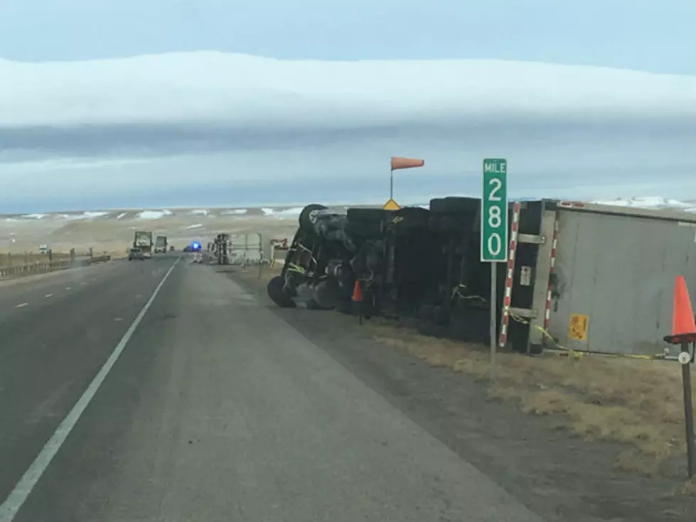
Portions of southeast Wyoming could see wind gusts around 65 mph today, according to the National Weather Service in Cheyenne.
High Wind Warnings are in effect until 6 p.m. this evening, which include Interstate 25 between Chugwater and Wheatland and Interstate 80 between Cheyenne and Laramie and near Arlington and Elk Mountain.
URGENT - WEATHER MESSAGE
National Weather Service Cheyenne WY
807 AM MDT Tue Oct 26 2021

WYZ106-270000-
/O.NEW.KCYS.FG.Y.0012.211026T1407Z-211026T1600Z/
/O.CON.KCYS.HW.W.0036.211026T1500Z-211027T0000Z/
Central Laramie Range and Southwest Platte County-
Including the city of Bordeaux
807 AM MDT Tue Oct 26 2021

...DENSE FOG ADVISORY IN EFFECT UNTIL 10 AM MDT THIS MORNING...
...HIGH WIND WARNING REMAINS IN EFFECT UNTIL 6 PM MDT THIS
EVENING...

* WHAT...For the High Wind Warning, west winds 30 to 40 mph with
  gusts up to 65 mph expected. For the Dense Fog Advisory,
  visibility less than one-quarter mile in dense fog.

* WHERE...Central Laramie Range and Southwest Platte County
  including Interstate 25 between Chugwater and Wheatland.

* WHEN...For the High Wind Warning, until 6 PM MDT this evening.
  For the Dense Fog Advisory, until 10 AM MDT this morning.

* IMPACTS...Mainly to transportation. Strong cross winds will be
  hazardous to light weight and high profile vehicles, including
  campers and tractor trailers. There will be a high risk for
  vehicle blow overs, particularly along north to south oriented
  roadways. Hazardous driving conditions due to low visibility.

PRECAUTIONARY/PREPAREDNESS ACTIONS...

A High Wind Warning means a hazardous high wind event is expected
or occurring. Sustained wind speeds of at least 40 mph or gusts
of 58 mph or more can lead to property damage.

If driving, slow down, use your headlights, and leave plenty of
distance ahead of you.
URGENT - WEATHER MESSAGE
National Weather Service Cheyenne WY
807 AM MDT Tue Oct 26 2021

WYZ116-117-270000-
/O.CON.KCYS.HW.W.0036.211026T1500Z-211027T0000Z/
South Laramie Range-South Laramie Range Foothills-
Including the cities of Buford, Pumpkin Vine, Vedauwoo, Whitaker,
Federal, and Horse Creek
807 AM MDT Tue Oct 26 2021

...HIGH WIND WARNING REMAINS IN EFFECT UNTIL 6 PM MDT THIS
EVENING...

* WHAT...West to northwest winds 30 to 40 mph with gusts up to
  65 mph expected.

* WHERE...South Laramie Range and South Laramie Range Foothills
  including Interstate 80 between Cheyenne and Laramie.

* WHEN...From 9 AM this morning to 6 PM MDT this evening.

* IMPACTS...Mainly to transportation. Strong cross winds will be
  hazardous to light weight and high profile vehicles, including
  campers and tractor trailers. There will be a high risk for
  vehicle blow overs, particularly along north to south oriented
  roadways.

PRECAUTIONARY/PREPAREDNESS ACTIONS...

A High Wind Warning means a hazardous high wind event is expected
or occurring. Sustained wind speeds of at least 40 mph or gusts
of 58 mph or more can lead to property damage.
URGENT - WEATHER MESSAGE
National Weather Service Cheyenne WY
807 AM MDT Tue Oct 26 2021

WYZ110-270000-
/O.CON.KCYS.HW.W.0035.000000T0000Z-211027T0000Z/
North Snowy Range Foothills-
Including the cities of Arlington and Elk Mountain
807 AM MDT Tue Oct 26 2021

...HIGH WIND WARNING REMAINS IN EFFECT UNTIL 6 PM MDT THIS
EVENING...

* WHAT...West to southwest winds 35 to 45 mph with gusts up to
  65 mph expected.

* WHERE...Interstate 80 near Arlington and Elk Mountain between
  mile markers 289 and 240.

* WHEN...Until 6 PM MDT this evening.

* IMPACTS...Mainly to transportation. Strong cross winds will be
  hazardous to light weight and high profile vehicles, including
  campers and tractor trailers. There will be a high risk for
  vehicle blow overs, particularly along north to south oriented
  roadways.

PRECAUTIONARY/PREPAREDNESS ACTIONS...

A High Wind Warning means a hazardous high wind event is expected
or occurring. Sustained wind speeds of at least 40 mph or gusts
of 58 mph or more can lead to property damage.

The NWS issued the following statement early Tuesday morning:

340 AM 10/26 – High Wind Watches and Warnings are in effect today with gusts 60 to 65 MPH possible across portions of southeast Wyoming and the Nebraska panhandle! High blow-over risk for light and high profile vehicles including camping and tractor trailers. For the latest road conditions in Wyoming, refer to www.wyoroad.info and for Nebraska, refer to www.511.nebraska.gov
RELATED:
LOOK: The most expensive weather and climate disasters in recent decades
Gallery Credit: KATELYN LEBOFF
More From 101.9 KING-FM