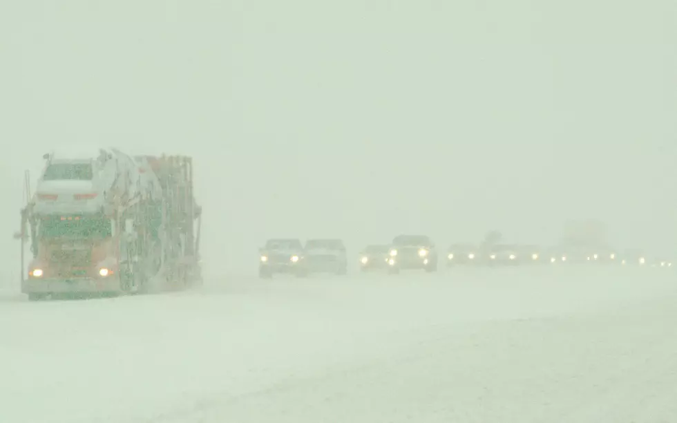
Snow & Wind Could Make for Dangerous Travel on I-80 Tonight
Up to a foot of mountain snow combined with winds gusting as high as 50 mph could make for dangerous travel along portions of Interstate 80 in southeast Wyoming tonight.
A High Wind Warning is in effect until 5 p.m. this afternoon for I-80 near Arlington and Elk Mountain; and a Winter Weather Advisory is in effect until 5 a.m. Wednesday for the Snowy and Sierra Madre Ranges.
High Wind Warning
URGENT - WEATHER MESSAGE
National Weather Service Cheyenne WY
239 AM MST Tue Feb 9 2021

WYZ110-100000-
/O.EXT.KCYS.HW.W.0013.000000T0000Z-210210T0000Z/
North Snowy Range Foothills-
Including the cities of Arlington and Elk Mountain
239 AM MST Tue Feb 9 2021

...HIGH WIND WARNING NOW IN EFFECT UNTIL 5 PM MST THIS
AFTERNOON...

* WHAT...West winds 35 to 45 mph with gusts up to 70 mph.

* WHERE...Interstate 80 Corridor near Arlington and Elk
  Mountain...between mile markers 252 and 283.

* WHEN...Until 5 PM this afternoon.

* IMPACTS...Mainly to transportation. Strong cross winds will be
  hazardous to light weight and high profile vehicles, including
  campers and tractor trailers. There will be a high risk for
  vehicle blow overs.

PRECAUTIONARY/PREPAREDNESS ACTIONS...

People should avoid being outside in forested areas and around
trees and branches. If possible, remain in the lower levels of
your home during the windstorm, and avoid windows. Use caution if
you must drive.

&&

$$

Rubin
Winter Weather Advisory
URGENT - WINTER WEATHER MESSAGE
National Weather Service Cheyenne WY
902 AM MST Tue Feb 9 2021

...COLD TEMPS IN THE TEENS AND SINGLE DIGIT CONTINUE NORTH OF A
DOUGLAS TO ALLIANCE LINE TODAY...

...SNOW AND BLOWING SNOW TODAY AND TONIGHT FOR THE SNOWY AND
SIERRA MADRE RANGES...

WYZ112-114-100015-
/O.CON.KCYS.WW.Y.0008.000000T0000Z-210210T1200Z/
Sierra Madre Range-Snowy Range-
Including the cities of Centennial and Albany
902 AM MST Tue Feb 9 2021

...WINTER WEATHER ADVISORY REMAINS IN EFFECT UNTIL 5 AM MST
WEDNESDAY...

* WHAT...Snow and blowing snow expected. Total snow
  accumulations of 6 to 12 inches. Winds gusting as high as 50
  mph.

* WHERE...Sierra Madre and Snowy Range Mountains.

* WHEN...Now through 5 AM Wednesday.

* IMPACTS...Dangerous travel due to icy, snow packed roads and
  very low visibilities in falling and blowing snow.

PRECAUTIONARY/PREPAREDNESS ACTIONS...

Slow down and use caution while traveling.

The latest road conditions for the state you are calling from can
be obtained by calling 5 1 1.

&&

$$

Braun

"As we get into the p.m. and overnight hours the southern mountains ... including I-80 between Laramie and Rawlins (are) going to start to pick up some snowfall," DayWeather meteorologist Mark Heuer said in a Monday afternoon WYDOT weather briefing.
"And with those winds of 40 to 50 mph, blowing snow, slick roads (and) reduced to poor visibility will be a threat on I-80 into the overnight hours," Heuer added.
Drivers are encouraged to call 511 or go to wyoroad.info for the latest road conditions.
MORE:
- 5 Things You May Not Have Known About Black Ice In Wyoming
- How To Keep Your Pets Safe in the Wyoming Cold – It’s Illegal Not To
- Is It Legal to Pass a Snowplow in Wyoming?
- Wyoming Road Info
The Worst Storms Of The Decade In Southeast Wyoming
More From 101.9 KING-FM


![‘High Impact’ Winter Storm to Hamper Wyoming Travel on I-25, I-80 [VIDEO]](http://townsquare.media/site/101/files/2019/10/crash-980.jpg?w=980&q=75)
